- Home
- About CATS
- The Transect
- Transect Codes Council
- Resources & Links
- Contact CATS
- CATS Programs
- Research
- Publications
- Education
- AWARDS
- CATS TOOLS
- Codes
- Modules
- Images
All images are available for free download for use in PowerPoint (low resolution) or print (high resolution), with credit as noted.
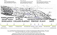 |
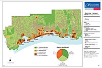
Regional Transect with Sectors & Communities A regional transect of natural conditions and existing thoroughfares, drawn in 1926 with compact towns and villages, is overlaid with the present SmartCode's three basic Community types in purple. The graph at the bottom shows how certain Open Space Sectors become Sending and Receiving areas for the Transfer of Development Rights (TDR) into Growth Sectors, thus protecting more open space from development. The T-zones of the classic rural-urban Transect are only used within the Community. Andrew von Maur, Andrews University 2008 RPAA 1926 |
 |
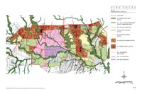
Early County, Georgia, Sector Plan This rural county is mapped for a regional and community-scale SmartCode. Most of the land is O-1 and O-2 Sectors, with Existing Communities (G-4 Infill Growth Sectors) and existing intersections already identified in the plan as locations for specific New Communities (G-1, G-2, or G-3 Sectors). If all possible Communities in a jurisdiction are identified, the Growth Sector and the Community Unit may be mapped as one and the same area, as they are here. If possible, lands in the O-2 Sector should be preserved as O-1 after the Transfer of Development Rights into the higher Growth Sectors. PlaceMakers LLC |
 |
East Edisto, South Carolina The East Edisto SmartCode is part of a long-range plan which will span 40-50 years. It regulates development in a contiguous area of nearly 80,000 acres and encompasses all scales of planning, from the region to the building. Created in collaboration with South Carolina's Dorchester and Charleston Counties, the plan is set within the planning context of the entire region. It is grounded in four cornerstones: rural character, environmental responsibility, sustainable towns and villages, and education and employment opportunities. While presenting a wide variety of rural to urban environments, spanning Community Units from Rural CLDs to the urban RCDs T1 to T5, the SmartCode calibration for East Edisto required a significant and fine-grained expansion of its field of application at the rural end of the Transect. In the illustration, the T1 Natural Zone is photographic because it exists, while the other zones are part of the future vision. The Transect is appropriately scaled for a typical community within the region. Hall Alminana, Inc. with Cooper Robertson & Partners; Legal Calibrator - William Wright |
 |
Fayetteville, Arkansas City Plan 2025 is an update to the Fayetteville Comprehensive Plan and serves as both a vision for the next 20 years and a roadmap for action. In 2006 over 700 community members participated in the hands-on charrette exercise that identified areas for growth and protection within the city. This input formed the basis for the Sector Plan, the cornerstone of the City Plan 2025 framework. The plan received awards from APA and CNU and citations from the EPA and Natural Resources Defense Council. An illustration of the Fayetteville downtown transect is available here. Dover, Kohl & Partners |
 |
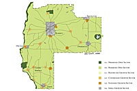
Lawrence, Kansas Sector Plan This Regional Sector plan is already implemented, as Lawrence has adopted it into their comprehensive plan. There is no G3 Intended Growth Sector because any new regional centers would compete with their historic downtown.
|
 |
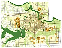
San Antonio City South Sector Plan Often there is no regional jurisdiction for coding standards, but here the city had annexed 80 square miles of ag land. A Toyota plant was coming into the area (dark purple), so growth would be sudden and development could be sprawling. This plan manages the growth by assigning Sectors by SmartCode Article 2. The targets represent the Communities and echo the Peter Calthorpe method. Duany Plater-Zyberk & Company |
 |
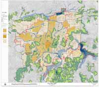
Mississippi Gulf Coast Regional Sector Plan The planning charrette held in Biloxi six weeks after Hurricane Katrina produced plans and codes for rebuilding the eleven cities along the Coast. This regional analysis shows the existing preserved open space, open space that should be preserved, and various growth sectors based on GIS. It does not assign the Community Scale shown on the other plans in this portion of the Image Library. Eliot Allen, Criterion / Mississippi Renewal Forum |
)
)
)
)
)
)
)