- Home
- About CATS
- The Transect
- Transect Codes Council
- Resources & Links
- Contact CATS
- CATS Programs
- Research
- Publications
- Education
- AWARDS
- CATS TOOLS
- Codes
- Modules
- Images
"A town is saved, not more by the righteous men in it than by the woods and swamps that surround it." — Henry David Thoreau
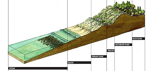
A transect is a cut or path through part of the environment showing a range of different habitats. Biologists and ecologists use transects to study the many symbiotic elements that contribute to habitats where certain plants and animals thrive.

Human beings also thrive in different habitats. Some people prefer urban centers and would suffer in a rural place, while others thrive in the rural or sub-urban zones. Before the automobile, American development patterns were walkable, and transects within towns and city neighborhoods revealed areas that were less urban and more urban in character. This urbanism could be analyzed as natural transects are analyzed.
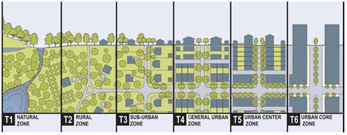
To systemize the analysis and coding of traditional patterns, a prototypical American rural-to-urban transect has been divided into six Transect Zones, or T-zones, for application on zoning maps. Standards were written for the first transect-based codes, eventually to become the SmartCode, which was released in 2003 by Duany Plater-Zyberk & Company.

This zoning system replaces conventional separated-use zoning systems that have encouraged a car-dependent culture and land-consuming sprawl. The six Transect Zones instead provide the basis for real neighborhood structure, which requires walkable streets, mixed use, transportation options, and housing diversity. The T‑zones vary by the ratio and level of intensity of their natural, built, and social components. They may be coordinated to all scales of planning, from the region through the community scale down to the individual lot and building, but the new zoning itself is applied at the community (municipal) scale.
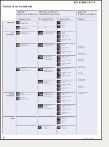
The T-zones are intended to be balanced within a neighborhood structure based on pedestrian sheds (walksheds), so that even T-3 residents may walk to different habitats, such as a main street, civic space, or agrarian land. The following table lays out the relationship of the region and community to the Transect Zones in the model SmartCode.
 The table to the left explains the nesting relationship of the scales of planning addressed in the SmartCode. Note that the six normative Transect Zones are not applied at the regional scale, as they are used for municipal zoning or to achieve balance in private developments.
As a shorthand, New Urbanist practitioners refer to the framework of the rural-to-urban transect used in this way simply as "the Transect." The benefits of using the Transect include
Codes and architectural pattern books based on the Transect must be calibrated for each place, to reflect local character and form. Depending on the place, there may be fewer or more T-zones determined by analysis. For example, most towns do not have a T-6 Urban Core Zone.
Although the model T-zone diagram is based on exemplary American urbanism, there have been numerous successes adapting the Transect methodology to the traditional patterns of other countries, including England, Scotland, Mexico, the Bahamas, Spain, Russia, and Romania. This is possible because nearly every town has some rural-to-urban gradient or distinctions, and code calibrators, like scientists in the field, analyze the components of the local transects to extract their DNA for coding for the future. The components include the disposition, configuration, and function of buildings, thoroughfares and civic space, which are coordinated by T-zone number to ensure "immersive environments," i.e., human habitats with distinctive character.
Because they are based on the physical form of the built and natural environment, all transect-based codes are form-based codes. The SmartCode, released in 2003, is the pioneering transect-based model code. The most up-to-date version is available free to municipalities and planning firms and may be downloaded here.
Practitioners are also studying regional transects for use in comprehensive plans and future inter-jurisdictional planning. The Regional Sector Plans of the SmartCode are based on natural regional transects, along with infrastructure such as existing or planned rail lines and thoroughfares.
Illustrative examples of regional and community-scale transects are available for download at our Image Library.
