- Home
- About CATS
- The Transect
- Transect Codes Council
- Resources & Links
- Contact CATS
- CATS Programs
- Research
- Publications
- Education
- AWARDS
- CATS TOOLS
- Codes
- Modules
- Images
All images are available for free download for use in PowerPoint (low resolution) or print (high resolution), with credit as noted.
 |
El Paso, Texas The Transect of El Paso ranges from the Plaza to the mountains, and illustrates the western Victorian and Foursquare architecture in T3 and T4, and the excellent T5 courtyard apartments. PlaceMakers and Geoff Dyer |
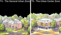 |
Fayetteville, Arkansas This reflects an idealized settlement pattern of the traditional city in the Ozarks; it was created by identifying and illustrating a range of conditions found in and around Fayetteville that embody the city’s vision for future development patterns. Dover, Kohl & Partners |
 |
Handsboro, Mississippi Among the oldest neighborhoods of Gulfport, with a typical Southern tree-lined residential street network, Handsboro is also one of its vital centers with the Cowan Road and Pass Road corridors intersecting at its heart. The Transect helps preserve the former while repairing the latter. Hall Alminana and Linda Weil |
 |
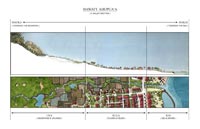
Hayward, California From its oak-studded foothills to its pre-WWII walkable neighborhoods and downtown, historic Hayward fully embodies a T1-T5 Transect. Hall Alminana prepared a Transit-Oriented SmartCode for 240 acres in the South Hayward BART Station Area that reflects the diverse culture, temperate climate and historic T4-T5 building patterns of this Transect. Several red-roofed civic buildings are prominent in the illustration. The BART station is shown in the upper right of T5. Hall Alminana, Inc. and Christopher Illustrations |
 |
Jamestown, Rhode Island This small island village, like many places on this page, has no T-6 zone. The local transect images were assembled to show citizens that the design team understood "their" T-zones. Sandy Sorlien and Donald Powers Associates |
 |
Maui, Hawaii The Hawaiian Mauka-Makai concept of orientation and habitation of the land is not a revival, but a survival. The terms used in this transect are in current daily use. Duany Plater-Zyberk & Company |
 |
Miami, Florida The standard T-zone diagram was adjusted for high-rise Miami to accommodate the sub-zones necessary to regulate several different height limits within T-5 and T-6. Duany Plater-Zyberk & Company |
 |
Post Falls, Idaho A commuter suburb of Spokane, Post Falls has experienced an increasingly common scenario: rapid, unfocused growth, without historic structures or a traditional Main Street. The transect encourages a new order. PlaceMakers and Dede Christopher |
 |
Richmond, Virginia The Richmond transect is comprised of six Character Areas that reflect physical specifics and set design norms according to context, ranging from the rapids of the James River corridor to the metropolitan core. The Character Areas are mapped in the Downtown Master Plan to instruct development and regulatory decisions. Dover, Kohl & Partners |
 |
Taos, New Mexico With over 400 years of built history, Taos has some of the most distinctive architectural and planning patterns in the US. The Taos T1 - T5 transect articulates this organic intricacy. PlaceMakers and Geoff Dyer |
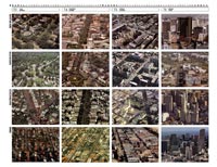 |
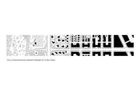
Transect of Four Cities This grid shows (top to bottom) New Orleans, Washington, San Francisco, and Miami. Studying cities by their local transects helps clarify differences and correlations from one city to another. Duany Plater-Zyberk & Company |
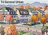 |
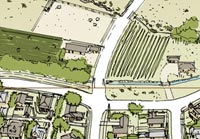
Tuxedo Reserve, New York Tuxedo Reserve, located 40 miles from New York City in the Hudson Valley, is a new mixed-use community to be developed adjacent to the historic Tuxedo Park built in the early 1900s. It offers a variety of rural to urban environments, encompassing T3, T4, and T5 zones. Over 70% of the total land area is to be preserved as T1-T2. This innovative illustration shows the T1 existing condition photographically and the planned habitats as watercolors. Hall Alminana, Inc. with Cooper, Robertson & Partners |
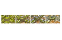 |
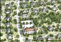
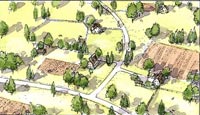
Vickery, Georgia This bird's eye transect is local in terms of the architectural syntax, and the illustration is notable for its clarity and austerity. It was used to explain the concept to charrette participants. Duany Plater-Zyberk & Company and Seth Harry |
 |
Washington, DC This diagram reflects the specific building and civic space types of Washington DC. Such local calibration is essential if SmartCodes are to avoid becoming as generic as conventional zoning ordinances. Duany Plater-Zyberk & Company and Dhiru Thadani |
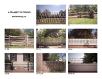 |
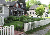
Williamsburg, Virginia This declension of fences supports a clear transect from edge to center, from countryside to King Street. If these familiar fence types are placed in the wrong Transect Zones, they become kitsch. Duany Plater-Zyberk & Company |
)
)
)
)
)
)
)
)
)
)
)
)
)
)
)